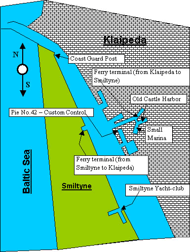
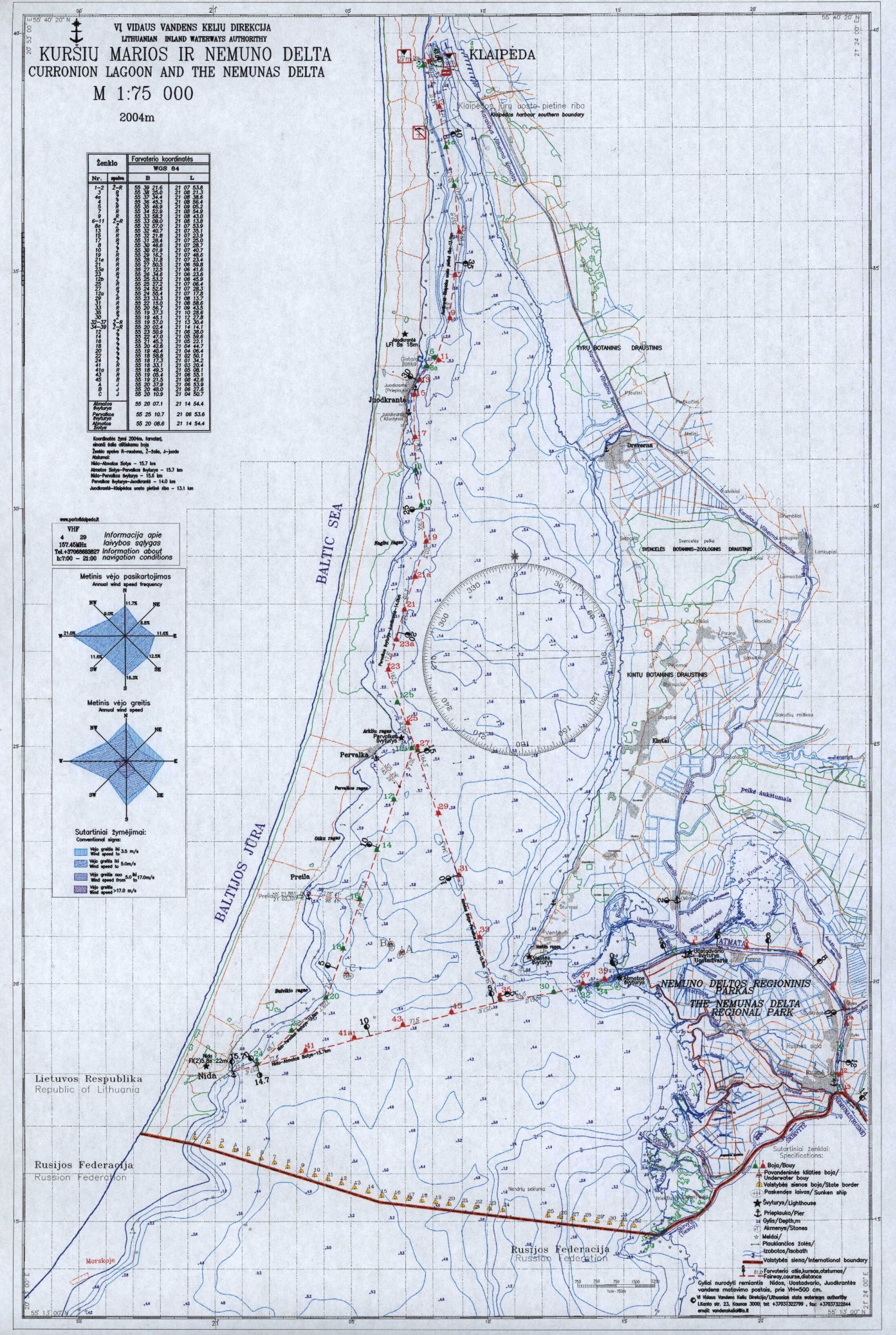
Entering port
- Entrance buoy 55° 43.791 N, 20° 59.746 E (all data are from 2004.06.27,
WGS84 standard).
- Centre of entrance (between breakwaters) 55° 43.697 N 21° 04.686
E.
- There is enough depth to enter from any direction.
- Recommended distance from the end of breakwaters:
- under calm conditions -
not less than 20 meters;
- under rough conditions -
centre of the entrance;
- Southern approaches deeper than Northern ones.
- Warning: remains of a vessel are visible at the end of the North breakwater.
The black buoy is the mark of NW approaches from the North breakwater.
- Depending on the wind direction, there can be a cross current across the
harbour mouth up to 1 knot northward when the wind direction is from S to
W.
- Prevailing wind directions round the year: W/SW.
- Harbour working 24 hours per day, 7 days per week.
- Harbour traffic control - VHF 9. Call sign - "Radio 5". Coastguarde
- VHF 9, call sign "Impuls 3".
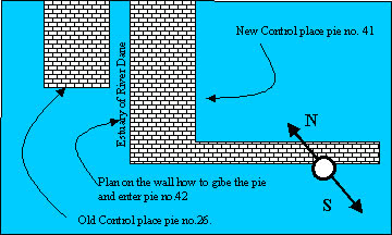
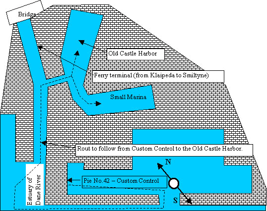
- It is mandatory (like in Soviet times) to announce departure and arrival to the Coast Guard (Impuls 3). For instance on approaches: "Impuls 3, Impuls 3, this is sailing yacht MIRA. Yacht is coming from Poland and going to the pie No.42 for pasport control procedure. Over" etc.) . It is recommended to standby on VHF 9 to be informed about ships' movements in the port (the deep water channel is rather narrow).
Navigation in Klaipeda harbour
- Currents in the harbour - up to 1.2 knots. Current direction depends on
wind:
- seaward when the wind direction
is from E to SW.
- inward when the wind direction
is from W to N.
- Lateral buoyage system (red to port when entering). Depth of deep-water
channel 10-12 m.
- Depth 30 meters from West bank is 5 m. East side is deep until bank.
- No hidden underwater obstacles in the port.
- Sailing is forbidden in the channel. You should follow under engine power.
- Crossing the main channel must be done at the angle of 90 degrees and is
only allowed when approaching vessels are at least 500 m away.
There is a special radio sign for Coast Guard on the channel 9 - "Impuls 3". Channel 16 (emergency) and 13 (bridge to bridge) is functional as well if there is some difficulties to use channel number 9.
Entering.
The Yacht Harbour is approximately 2 NM from Klaipeda port entrance, to starboard.
Position of Yacht Harbour entrance: 55° 41.847 N 21° 07.250 E.
- There are two connected basins: new and old.
New basin: Turn sharp to the port when entering Yacht Harbour.
- Depth from 3 m. in the North to 2.5 m. in the South, no limits for mast
height.
- Boat berths are equipped with steel posts maximum 4.5 metres width in-between.
- Distance from posts to the concrete quay is approximately 24 metres.
- New basin not directly visible from watchman's position.
Old basin: Straight on when entering Yacht Harbour (the northern basin)
- Depth: 2.8 m in the East to 2.1 m in the West (low water), no limits for
mast height.
- Boat berths are equipped with wooden poles maximum 3.5 m. width in-between.
- Distance between poles and concrete quay varies from 14 m. to 20 m.
- The old basin is completely visible from the watchman's position.
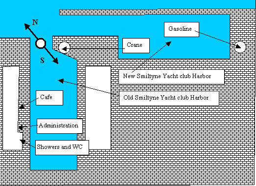
Facilities
- fresh water (taps at various places around the basins)
- electricity 220 V, standard european plug (2 pins plus ground connection)
- there is no posibility to fill-in a fuel tanks in Smiltyne jachtclub
- toilets, showers, washbasins (separate male/female). No laundry equipment
- sailmaker, carpenter, mast crane (2 tones)
- café, also for simple meals. Hot meal 8-12 LTL. Light beer 0.5 ltr
3.5 LTL. Wine, beer and light alcohol up to 20 degrees strong available. .
No strong drinks. Payment is in local currency.
- 24-hour security. There are four people working in shifts, changing over
every 24 h at 9:00 am. The main watchman's duties include boat safety and
security, payment collection, cleaning, distributing shower keys. It is secure
to leave the boat in the harbour. Due to significant distance from the city
strangers are rare. Any way it is recommended to lock the cabin in case of
departure to the city. Things on deck are secure. Harbour watch phone +370
46 391131
Cost: 4 LTL/LOA(m)/day plus 6 LTL person/day; this includes mooring fee, water,
electricity, security, shower.
All services are located in two floors administrative building on the Northern
shore of the harbour.
Available places for visitors: 15 (boats).
Payment for the stay in the harbour - at the harbourmaster's room on the second
flour.
Klaipeda town from yachtclub can be reached by ferry. Departure place named
"Smiltyne" and located 1 km to the North from yacht club. Arrival
- "Dange" river estuary (and city center). Frequency - each hour:
XX:15 - from Smiltyne, XX:00. Working hours in high season (1 of May - 30
September) 5 a.m. - 2:15 a.m. Schedule in low season is different. Always
is worth to pick-up schedule brochure, which is available at the ferry free
of charge (ferry homepage http://www.keltas.lt/en/).
The sandy beach of sea from yachtclub can be reached after a 1,5 km walk through
the forest.
The sea museum is 3 km away to the North from yachtclub.
Nida (summer resort on the Curonian Spit) is 51 km away to the South by bus
from Smiltyne ferry marina.
Sailing in the internal Laguna (Curonian Lagoon - Kursiu Marios
- Kursiu Laguna)
- Size of the Laguna: 23 NM (S to N) to the Russian border, 5 NM max E to
W.
- The depth in the Laguna Channel is approximately 2.5 m. Depending on wind
and barometric pressure, the depth can vary by 0.3 m.
- The Laguna Channel starts at the end of Klaipeda harbour near the island
"Kiaules Nugara" ("Pork's Back"). This island should be
left to port. (East)
Do NOT use the channel to the East of the island. First, the East channel
is not deep enough, second, high voltage wires cross the East channel at a
height of 8 to 9 m! (they cross the West channel at 28 m)
- The narrowest part of Laguna Channel is near Juodkrante.
- There are many fishing nets, fastened to poles, in the Laguna. Usually the
depth near the last pole (from both sides) is 3 m. It is safe to pass the
last pole even in 1 metre distance.
- It is strongly recommended to follow the channel from Kiaules Nugara island
to the Roterman light house. This channel is buoyed and provided with lights.
After the light house the depth increases. The lighthouse is located near
city "Pervalka". In this place fireway has split: to the Nemunas
delta and to the Nida city.
- The sandbanks direction around the light house - to the East and to the
West till the shore. Secure distance from the East approaches - 0.3 NM.
- After Roterman light house there is enough deep between Nida Channel (marked
by unlit green buoys and Nemunas Channel (marked with black lightbuoys).
- There is a long sandbank from Bulvikio cape, the last cape before Nida.
It is strongly recommended to pass East of the green buoy.
- 0.3 NM before the green buoy of Bulvikio cape there is a barge wreck marked
by a black/yellow lightbuoy. In rough conditions, only the chimney of the
barge is visible, some 10 m NW of the lightbuoy.
- The green buoy between Bulvikio cape and Nida should be passed East as well.
- There are two harbours in Nida: fisherman's' - Northern entrance, and guest
harbour - Southern one. To avoid sandbanks it is recommended not to cross
the straight line from the last green buoy to the fishermen harbour entrance.
- Guest harbour approaches are secure from any direction. Harbour has white
mooring buoys 20-25 m away from the concrete quay to the West.
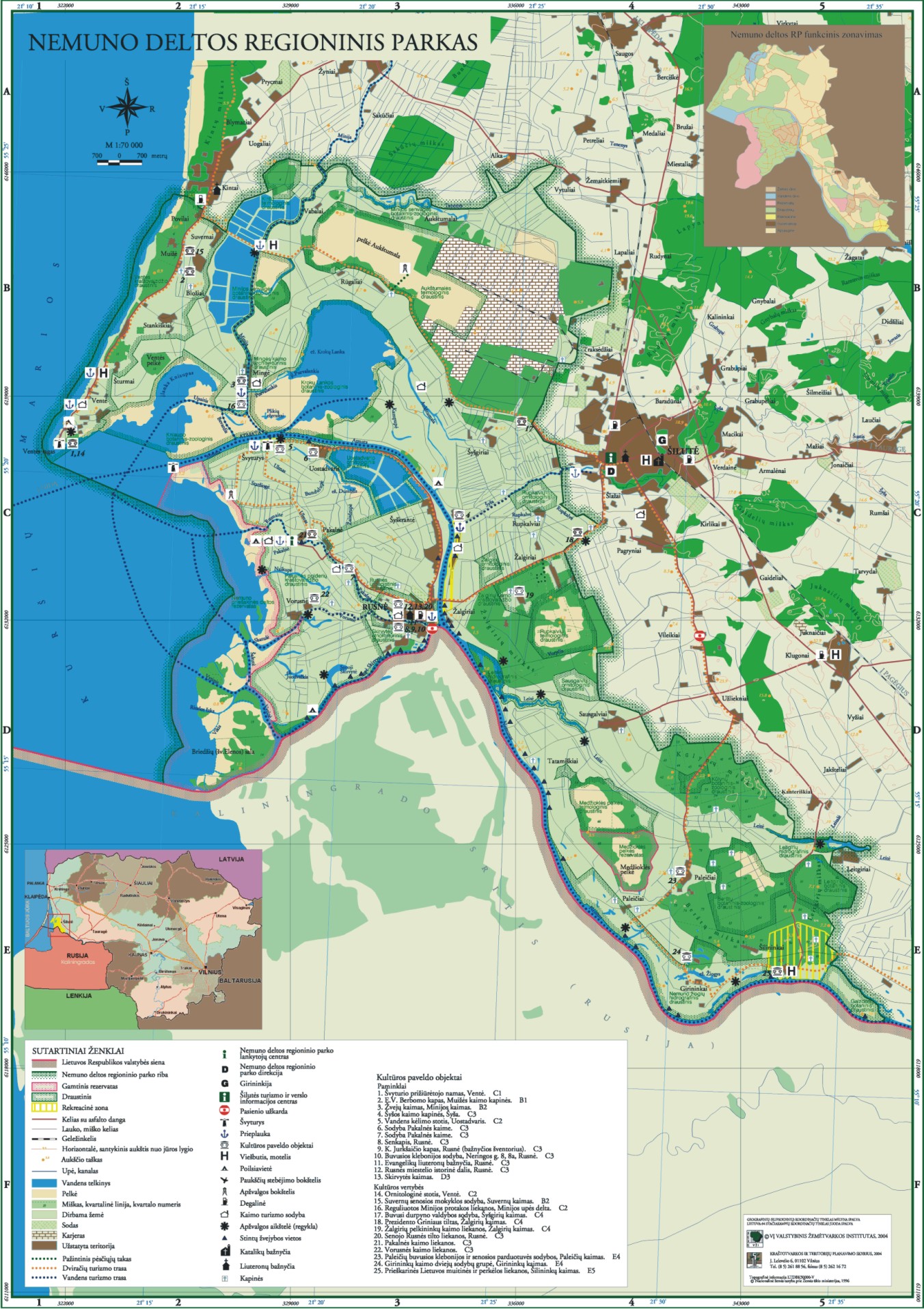
Useful links: Sea Map of Curonian Lagoon (.jpg 974 Kb) and Limiting Coordinates of the Curonian Lagoon Fairway 2004 (.doc 60.5 Kb). The regional park of Nemuna's delta, Nemuna's delta map.
Prepared by sailing captain Arturas Dovydenas, s/y "BLUE BIRD"